Camarines Norte
| Camarines Norte | |||
|---|---|---|---|
| — Province — | |||
|
|||
 |
|||
| Coordinates: | |||
| Country | |||
| Region | Bicol Region (Region V) | ||
| Founded | — | ||
| Capital | Daet | ||
| Government | |||
| - Governor | Edgardo Tallado (Partido Liberal ng Pilipinas) | ||
| Area | |||
| - Total | 2,320.07 km2 (895.8 sq mi) | ||
| Area rank | 57th out of 80 | ||
| Population (2007) | |||
| - Total | 513,785 | ||
| - Rank | 51st out of 80 | ||
| - Density | 221.5/km2 (573.6/sq mi) | ||
| - Density rank | 33rd out of 80 | ||
| Divisions | |||
| - Independent cities | 0 | ||
| - Component cities | 0 | ||
| - Municipalities | 12 | ||
| - Barangays | 282 | ||
| - Districts | Lone district of Camarines Norte | ||
| Time zone | PHT (UTC+8) | ||
| ZIP Code | |||
| Spoken languages | Bikol, Tagalog | ||
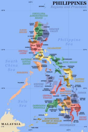
Camarines Norte is a province of the Philippines located in the Bicol Region in Luzon. Its capital is Daet and the province borders Quezon to the west and Camarines Sur to the south.
Contents |
Demographics
Camarines Norte has a population of 513,785 as of CY 2007, roughly 10% of the region's population of 5,109,798 and 0.62% of the country's population of 88,574,614.. Bikol is the major language spoken, together with Tagalog and English.
Economy
The four major manufacturing and processing industries in the province are jewelry craft, gifts/toys/housewares, pineapple and coconut industry.
Geography
The province of Camarines Norte is found in the northwestern coast of the Bicol Peninsula, which form the southeastern section of Luzon, the largest island in the Philippine archipelago.
One of the six provinces that make up Region V (Bicol), it is bounded on the north by the Pacific Ocean, in the east by the Pacific Ocean and San Miguel Bay, in the west of Lamon Bay, and in the south by Quezon province and the adjoining province of Camarines Sur.
Its capital town, Daet, is 342 kilometers southeast of Metro Manila, a 7-hour drive by bus or a 45-minute trip by plane.
History
Bicol province was founded in 1573. The province of Camarines was created from Bicol in 1636. That province was divided in 1829, creating Camarines Norte and Camarines Sur. They were briefly merged from 1854 to 1857 to make Ambos Camarines (ambos is Spanish for "both"). They were merged into Ambos Camarines once again in 1893. The province was divided into Camarines Norte and Camarines Sur once again in 1917.
Political
Camarines Norte is subdivided into 12 municipalities.
| Municipality | No. of Barangays |
Area (km²) |
Population (2007) |
|
|---|---|---|---|---|
| Basud | 29 | 260.28 | 36,763 | |
| Capalonga | 22 | 290.00 | 29,683 | |
| Daet (Capital Town) | 25 | 46.00 | 94,184 | |
| Jose Panganiban | 27 | 214.44 | 49,028 | |
| Labo (Largest Municipality) | 52 | 589.36 | 88,087 | |
| Mercedes | 26 | 173.69 | 44,375 | |
| Paracale | 27 | 197.90 | 46,856 | |
| San Lorenzo Ruiz | 12 | 119.37 | 12,299 | |
| San Vicente | 9 | 57.49 | 9,615 | |
| Santa Elena | 19 | 199.35 | 40,300 | |
| Talisay | 15 | 30.76 | 22,942 | |
| Vinzons | 19 | 141.43 | 39,653 | |
Infrastructure
The province has an international seaport located at Barangay Osmeña, Jose Panganiban town servicing one of its major industries, Pan Century Surfactants. The seaport is approximately five kilometers from the town proper and an hour ride to the capital town of Daet.
The province also has 13 fishing ports in the coastal municipalities and one feeder airport in Bagasbas, Daet.
External links
- WowBicol.com
- WOW Philippines - Camarines Norte
- Bicolanoes.com
- www.bicolonline.com
- http://camnorte.bicolonline.com
- http://www.camarinesnorte.gov.ph Official website
- http://chat.daetonthego.com LiveChat
- Domain Name Provider in Camarines Norte
- Jose Panganiban Elementary School
|
|||||

